Inova GIS Platform
INOVA GIS Platform is a set of software tools (including TeleCAD-GIS) that make up a complex information system intended primarily for telecom operators (enteris GIS).
The purpose of the system is to improve the management of the total telecommunications infrastructure owned by the telecom operator and to enable integration with other information systems owned by the operator.
The system enables telecommunications infrastructure management having in mind its geometric component. In other words it enables you to design digital representation of real world physical telecommunication infrastructure. This digital representation fully depicts physical geometry and corresponding relations between physical elements found on the field.
- TeleCAD-GIS
- IGS (INOVA GIS Server)
- iPLAN
- TCG Map - Optic
The platfrom includes:
Whom is it for?
- Fiber optic cables,
- Copper cables,
- Coaxial cables and
- Conduits.
INOVA GIS Platform is used by telecommunications companies that among their assets have networks of:
Advantages
The platform enables for entire network to be documented in one place. This is, no doubt, much better solution than having documentation scattered in different files or even paper documentation. Analyzing or updating such documentation can be a daunting task.On the other hand, with centralized Enterprise GIS, these actions are not just faster and easier but they are absolutely accurate. Updates are made in one place only (GIS database) and all documentation and reports are generated from a single source.

Platform architecture
- Data tier
- Middle (Server) tier
- Presentation and editing (Client) tier
Inova GIS Platform is a multi-user system where three tier architecture design pattern was applied making it a modular software package with clearly defined:
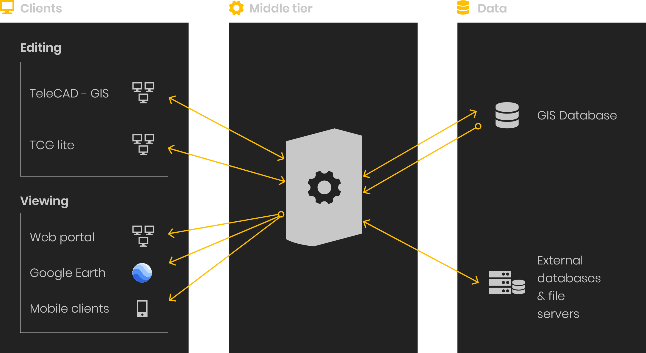
Data tier (gis data base)
Platform is implemented with Oracle 11G Standard Edition. No additional spatial cartridge is required!
Spatial capabilities are achieved through the use of INOVA GIS Server (IGS). Data is stored in Oracle tables making them visible to various third party tools such as Crystal Reports, ESRI ArcView etc.
Middle tier – INOVA GIS Server (IGS)
INOVA GIS Server enables virtually unlimited number of concurrent users to be connected to GIS database. Some of the IGS features are: Scalability, Long Transactions, Versioning, Object Locking, Project work flow, Offline file project synchronization, User Access rights, Middle tire application logic, WMS/WFS MAP Server, Service-oriented architecture (SOA), Linq2SQL custom data model
Presentation and editing (Client) tier
The “client” is a software application which the users are in direct contact with.
Data (infrastructure) stored in the GIS database can be accessed in many different ways. What tools shall be used depends on the type of user (engeenier, manager) as well as on their intention (editing, viewing, presenting, analysing)
TeleCAD-GIS (designing, editing, maintaining, viewing); TCG Map Optics – Custom WEB and Desktop Client User control; Viewing content using Web Browser (data is presented through Web Portal); Viewing content using third party software (Google Earth); Viewing content using mobile devices
TeleCAD - GIS
TeleCAD-GIS is the main and most comprehensive tool for working with the telecommunications infrastructure, generating reports and documentation etc. It comes as a standalone product or as a part of INOVA GIS Platform. TeleCAD-GIS is what clients (mostly engineers) see while they work with the telecommunications infrastructure including working with GIS database
Find out more about TeleCAD-GIS here.
TCG Map-Optic
TCG Map-Optics is a component of TeleCAD-GIS. At the same ime it is available as a standalone application. It is a tool for direct viewing, analyzing and editing the data stored in the GIS database.
Map view and Schematic Diagram view are used to navigate the infrastructure with ease and to perform other complex tasks such as marking the fault location (OTDR trace) or tracing the available path between arbitrary points of the network while applying different criteria.
TCG Map-Optics has similar functions when used as a standalone application as it does when used within TeleCAD-GIS.
Gis web portal
GIS portal can be accessed with any web browser (no need for any additional plugins). It is used for viewing data stored in GIS database. This is very valuable to the people without required technical knowledge that is otherwise needed to operate tools such as TeleCAD-GIS.
It is possible to control what type of information will be presented. Information can be presented internally within a company or publicly over the internet.
Engineers get a quick overview of existing infrastructure throughout the network, workers in the sales get a quick overview of all the nearest available capacity and management gets a set of reports implemented through thematic maps.
GIS Portal can be integrated with popular Internet services for maps (Google Maps, Bing, OpenStreet …) which can be used as base maps to view GIS content.
Portal allows searching of all elements of the infrastructure (distribution frames, optical interconnections, leased cables, etc.) according to different criteria and their position on the map. It allows import of additional maps and GIS layers: an administrative division (municipality, populated areas), infrastructure from other domains (water supply network, power network, gas), cadastral maps, etc. It contains a set of predefined tabular reports as well as reports in the form of thematic maps. Reports are configurable, no additional programming is needed to add new reports.
Viewing content using third party software (Google Earth)
GIS data can be published as a KML stream. This makes it possible to be viewed using Google Earth application. All of the objects from the GIS database are presented as defined within Internet map server. There is no need for additional activities in the form of exporting or the preparation of objects. The data is distributed in the real time to the Google Earth clients in the KML format. Conversion between different coordinate systems is performed automatically by INOVA GIS Server.
Google Earth application enables presentation of the infrastructure from the central GIS database overlying the 3D terrain and it enables users who are not from engineering profession to have a quick and simple view into the GIS data.
Viewing and editing using mobile devices
GIS database can be viewed on mobile devices using any standard web browser.
Also, object model is provided for Trimble GPS devices. This way, field workers can assign a telecommunications infrastructure objects (defined in the model) to a surveyed location or path during the field survey process itself. This way surveyed paths instantly become cables, duct banks and locations become splice points, ODFs, telephone poles, Manholes etc. Right there on the field, in an offline mode, infrastructure can be viewed, properties can be edited and new objects can be added. Process is completed upon the return from the field to the office by exporting surveyed data to TeleCAD-GIS. TeleCAD-GIS is then used to analyze data, fill in additional information (e.g. splicing) and update the GIS database.